About Israel
Israel is a small country located in the eastern Mediterranean, bordered by Lebanon to the north, Syria to the northeast, Jordan to the east, and Egypt to the southwest. It is a holy land for three of the world’s major religions: Judaism, Christianity, and Islam.
Some interesting facts about Israel |
|
|---|---|
| Capital | Jerusalem (recognized by Israel, but not by many other countries) |
| Largest City | Tel Aviv |
| Official Languages | Hebrew, Arabic |
| Population | Approximately 9 million |
| Currency | Israeli New Shekel (ILS) |
| Government | Parliamentary democracy |
| President | Isaac Herzog |
| Prime Minister | Naftali Bennett |
| Religion | Jewish (74%), Muslim (17%), Christian (2%), Druze (2%), other (5%) |
| Highest Point | Mount Meron (1,208 meters/3,963 feet) |
| Lowest Point | Dead Sea (-430 meters/-1,411 feet) |
| National Symbol | Menorah (a seven-branched candelabrum) |
| National Holidays | Independence Day (April/May), Yom Kippur (September/October), Passover (March/April), Hanukkah (November/December) |
| Famous Landmarks | Western Wall, Masada, Old City of Jerusalem, Dead Sea, Yad Vashem Holocaust Museum |
Flag of Israel
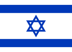
A blue and white striped banner with the Star of David in the center.
History of Israel
The land that is now Israel has a long and complex history, dating back thousands of years. It has been inhabited by various peoples and empires over the centuries, including the Canaanites, Israelites, Persians, Greeks, Romans, Byzantines, Arabs, Crusaders, Ottomans, and British.
One of the most significant events in Israel’s history was the establishment of the state of Israel in 1948, following the end of British mandate rule in Palestine. This event was accompanied by a war between Israel and its neighboring Arab states, which displaced hundreds of thousands of Palestinians.
Israel has been embroiled in a long-standing conflict with its neighbors over issues such as borders, settlements, and the status of Jerusalem. There have been several wars and numerous peace negotiations, but a lasting resolution to the conflict has yet to be achieved.
Geography
Israel is a small country located in the eastern Mediterranean, bordered by Lebanon to the north, Syria to the northeast, Jordan to the east, and Egypt to the southwest. It has a total area of approximately 22,000 square kilometers (8,500 square miles), making it roughly the size of New Jersey.
Israel boasts a diverse and varied landscape, including mountains, deserts, and coastal plains. The highest point in Israel is Mount Meron, which stands at 1,208 meters (3,963 feet) above sea level, while the lowest point is the Dead Sea, which is 430 meters (1,411 feet) below sea level.
Physical features
Mountains in Israel
| Mount Meron | The highest peak in Israel, standing at 1,208 meters (3,963 feet) above sea level, is in the Upper Galilee region. |
| Mount Hermon | A mountain range on the border between Israel and Syria, with the highest peak reaching 2,814 meters (9,232 feet) above sea level. |
| Judean Mountains | A range of hills runs from central Israel to the west bank of the Jordan River, with the highest peak being Har Eitan at 1,028 meters (3,373 feet) above sea level. |
Valleys in Israel
| Jordan Rift Valley | A geological feature extending from northern Syria to the Red Sea, running through the center of Israel and forming the border with Jordan. |
| Jezreel Valley | A large fertile plain in northern Israel, known for its agricultural productivity and historical significance. |
| Coastal Plain | A narrow strip of land along the Mediterranean Sea stretches the length of Israel’s western coast. |
Rivers in Israel
| Jordan River | A major river in the Middle East, forming the border between Israel and Jordan and running from the Sea of Galilee to the Dead Sea. |
| Yarkon River | A river in central Israel that flows through Tel Aviv and into the Mediterranean Sea. |
Lakes in Israel
| Sea of Galilee | A freshwater lake in northern Israel, also known as Lake Kinneret, which is an important source of water for the region. |
| Dead Sea | A saltwater lake located in the Jordan Rift Valley, known for its high salt and mineral content and for being the lowest point on Earth. |
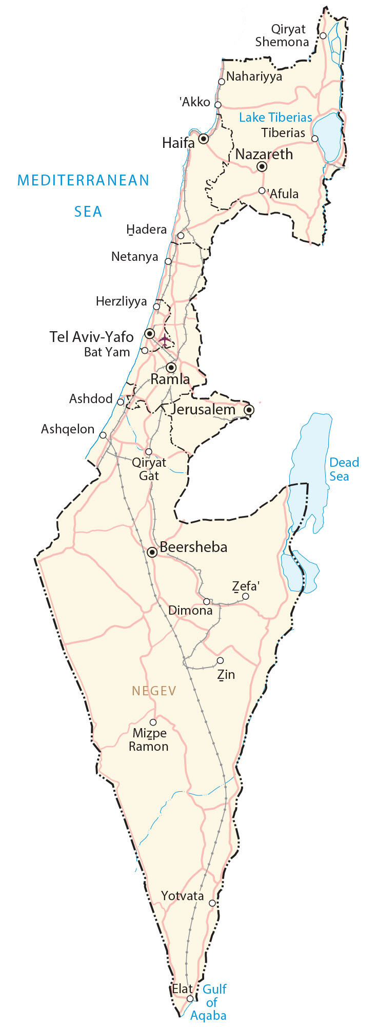
Cities and towns in Israel
| City/Town | Region | Population | Description |
|---|---|---|---|
| Jerusalem | Jerusalem District | 936,425 | The capital city of Israel is located in the Judean Mountains. It is considered a holy city for Jews, Christians, and Muslims, and is home to many historical and religious sites, such as the Western Wall, the Church of the Holy Sepulchre, and the Dome of the Rock. |
| Tel Aviv | Tel Aviv District | 460,613 | The largest city in Israel, located on the Mediterranean coast. It is known for its lively nightlife, beaches, and cultural attractions, and is often referred to as the “city that never sleeps.” |
| Haifa | Haifa District | 284,449 | A port city located on the slopes of Mount Carmel, known for its mix of Jewish and Arab culture, as well as its scenic views and attractions such as the Baha’i Gardens. |
| Rishon LeZion | Central District | 266,091 | The fourth largest city in Israel, located south of Tel Aviv. It is a major center for industry and commerce and is also home to the country’s largest indoor shopping mall. |
| Ashdod | Southern District | 242,054 | A port city on the Mediterranean coast, located between Tel Aviv and Gaza. It is an important center for shipping and trade and is home to one of Israel’s largest industrial zones. |
| Petah Tikva | Central District | 243,031 | A city located east of Tel Aviv, known for its high-tech industry and medical facilities. |
| Netanya | Central District | 223,933 | A coastal city north of Tel Aviv, known for its beaches and tourist attractions. |
| Beersheba | Southern District | 218,320 | The largest city in the Negev desert, known for its desert landscapes and its importance as a center for technology and defense industries. |
| Nazareth | Northern District | 77,032 | A city in the Galilee region, known as the childhood home of Jesus and for its significance in Christian history. |
| Safed | Northern District | 35,203 | A small city in the Upper Galilee region, known for its ancient synagogues, mystical heritage, and artist colony. |
Transportation
Highways in Israel
| Highway 1 | Also known as the “Jerusalem-Tel Aviv Highway,” it is a major highway connecting the two cities and serving as the main transportation artery in the country. |
| Highway 2 | A coastal highway running the length of Israel’s Mediterranean coast, connecting Tel Aviv with Haifa and other northern cities. |
| Highway 6 | A toll road is also known as the “Trans-Israel Highway,” runs north to south and connects the major cities of Israel. |
Airports
| Ben Gurion International Airport | Israel’s main airport, located near Tel Aviv and serves as the hub for El Al, Israel’s national airline. |
| Eilat Airport | A small airport located in the southern city of Eilat, serving domestic and international flights. |
| Haifa Airport | A regional airport serving the northern city of Haifa and the surrounding region. |
Tourist Attractions in Israel
| Point of Interest | Region | Description |
|---|---|---|
| Old City of Jerusalem | Jerusalem District | A walled city in the heart of Jerusalem, containing many historical and religious sites, such as the Western Wall, the Church of the Holy Sepulchre, and the Dome of the Rock. |
| Masada | Southern District | An ancient fortress located atop a mountain overlooking the Dead Sea is known for its tragic history as the site of a mass suicide of Jewish rebels during the Roman siege. |
| Dead Sea | Southern District | A saltwater lake located in the lowest point on earth, known for its therapeutic properties and unique ecosystem. |
| Caesarea | Haifa District | An ancient port city built by Herod the Great, containing many well-preserved ruins such as a Roman theater and aqueduct. |
| Baha’i Gardens | Haifa District | A series of terraced gardens surround the Shrine of the Bab, a Baha’i holy site located on the slopes of Mount Carmel. |
| Tel Aviv Boardwalk | Tel Aviv District | A long promenade running along the Mediterranean coast is known for its beaches, cafes, and street performers. |
| Yad Vashem | Jerusalem District | Israel’s official memorial to the victims of the Holocaust, contains a museum, archives, and a Hall of Remembrance. |
| Rosh Hanikra | Northern District | A series of grottoes and caves located on the Mediterranean coast near the border with Lebanon, known for its turquoise waters and stunning views. |
| Sea of Galilee | Northern District | A freshwater lake located in the Galilee region, known for its biblical history and as a popular destination for boating, fishing, and hiking. |
| Timna Park | Southern District | A geological and archaeological park located in the Negev desert, containing natural wonders such as the Mushroom Rock and the Arches, as well as ancient copper mines and rock art. |
Top FAQs on Israel
FAQ #1: How Big is Israel?
Ans: Israel covers a total area of approximately 22,145 square kilometers (8,550 square miles).
Faq #2: What is the capital of Israel?
Ans: The designated capital of Israel is Jerusalem.
Faq #3: How many tribes of Israel?
Ans: There are twelve(12) tribes of Israel.
Faq #4: Who was the first king of Israel?
Ans: Saul was the first king of Israel, according to the Hebrew Bible.
Faq #5: What language is spoken in Israel?
Ans: Hebrew.
Faq #6: When did Israel become a nation?
Ans: On May 14, 1948.
Faq #7: Does Israel have nuclear weapons?
Ans: The country is estimated to have nuclear warheads of approximately 90 warheads.
Faq #8:Is Israel part of Nato?
Ans: Israel is not a part of NATO.
FAQ #9: Is Jerusalem in Israel?
Ans: Yes