About Virginia County
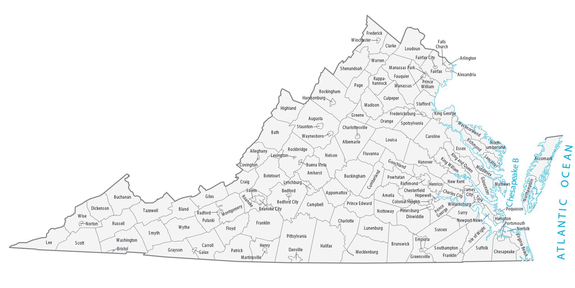
Virginia is divided into 95 counties, each with its own local government. The county system in Virginia dates back to the colonial era, when the colony was divided into “shires” or “counties” to facilitate local governance. Today, Virginia’s counties are responsible for a variety of services and functions, including law enforcement, education, public works, and land use planning.
Each county in Virginia has a county seat, which is usually the largest town or city within the county. The county seat serves as the administrative center of the county, where the county government offices and courthouse are located.
The population and size of Virginia’s counties vary widely. The most populous county in Virginia is Fairfax County, with a population of over 1.1 million people, while the least populous county is Highland County, with just over 2,000 people. In terms of size, the largest county in Virginia is Pittsylvania County, which covers over 970 square miles, while the smallest county is Arlington County, which covers just 26 square miles.
Virginia Map
Virginia is a state located in the southeastern region of the United States. It is bordered by Maryland to the north, the Atlantic Ocean to the east, North Carolina and Tennessee to the south, and Kentucky and West Virginia to the west.
Virginia is known as the “Mother of Presidents” because it is the birthplace of eight U.S. Presidents, including George Washington, Thomas Jefferson, James Madison, James Monroe, William Henry Harrison, John Tyler, Zachary Taylor, and Woodrow Wilson.
Virginia has a diverse economy that includes agriculture, manufacturing, and service industries. Major industries in Virginia include technology, defense, tourism, and healthcare. The state is also home to several military installations, including the Pentagon and Naval Station Norfolk, making it an important center of military activity.
List of all Virginia Counties |
||
|---|---|---|
| County | Population | Area (sq. mi) |
| Accomack | 32,318 | 1,310 |
| Albemarle | 110,442 | 725 |
| Alleghany | 14,086 | 447 |
| Amelia | 14,635 | 359 |
| Amherst | 31,169 | 475 |
| Appomattox | 16,304 | 333 |
| Arlington | 237,521 | 26 |
| Augusta | 77,756 | 970 |
| Bath | 4,084 | 532 |
| Bedford | 78,319 | 754 |
| Bland | 6,296 | 359 |
| Botetourt | 34,503 | 545 |
| Brunswick | 16,580 | 566 |
| Buchanan | 22,405 | 502 |
| Buckingham | 17,577 | 583 |
| Campbell | 55,174 | 504 |
| Caroline | 31,710 | 528 |
| Carroll | 29,149 | 478 |
| Charles City | 6,986 | 182 |
| Charlotte | 11,826 | 474 |
| Chesterfield | 349,556 | 423 |
| Clarke | 14,354 | 176 |
| Craig | 5,171 | 330 |
| Culpeper | 53,684 | 379 |
| Cumberland | 9,983 | 299 |
| Dickenson | 14,162 | 333 |
| Dinwiddie | 27,757 | 504 |
| Essex | 10,470 | 257 |
| Fairfax | 1,159,748 | 406 |
| Fauquier | 73,553 | 651 |
| Floyd | 15,393 | 382 |
| Fluvanna | 28,648 | 290 |
| Franklin | 56,509 | 692 |
| Frederick | 94,844 | 413 |
| Giles | 16,249 | 358 |
| Gloucester | 37,165 | 216 |
| Goochland | 25,089 | 288 |
| Grayson | 15,022 | 443 |
| Greene | 20,877 | 157 |
| Greensville | 11,390 | 296 |
| Halifax | 33,541 | 816 |
| Hanover | 109,228 | 469 |
| Henrico | 340,406 | 243 |
| Henry | 50,258 | 382 |
| Highland | 2,139 | 416 |
| Isle of Wight | 38,538 | 318 |
| James City | 79,116 | 142 |
| King and Queen | 7,055 | 314 |
| King George | 27,791 | 179 |
| King William | 17,203 | 275 |
| Lancaster | 10,553 | 134 |
| Lee | 22,701 | 438 |
| Loudoun | 420,001 | 521 |
| Louisa | 38,304 | 497 |
| Lunenburg | 12,097 | 434 |
| Madison | 13,146 | 322 |
| Mathews | 9,773 | 87 |
| Mecklenburg | 30,327 | 625 |
| Middlesex | 10,947 | 131 |
| Montgomery | 100,757 | 387 |
| Nelson | 15,177 | 471 |
| New Kent | 24,942 | 211 |
| Northampton | 11,578 | 212 |
| Northumberland | 12,424 | 193 |
| Nottoway | 15,299 | 314 |
| Orange | 37,959 | 342 |
| Page | 24,758 | 311 |
| Patrick | 17,811 | 484 |
| Pittsylvania | 60,197 | 969 |
| Powhatan | 30,150 | 262 |
| Prince Edward | 22,513 | 352 |
| Prince George | 39,512 | 265 |
| Prince William | 486,472 | 338 |
| Pulaski | 34,166 | 321 |
| Rappahannock | 7,261 | 267 |
| Richmond | 8,798 | 191 |
| Roanoke | 94,440 | 250 |
| Rockbridge | 22,475 | 598 |
| Rockingham | 82,400 | 851 |
| Russell | 27,695 | 474 |
| Scott | 20,777 | 538 |
| Shenandoah | 42,224 | 511 |
| Smyth | 30,051 | 452 |
| Southampton | 17,023 | 603 |
| Spotsylvania | 139,118 | 412 |
| Stafford | 152,882 | 271 |
| Surry | 6,982 | 279 |
| Sussex | 11,435 | 491 |
| Tazewell | 42,461 | 520 |
| Warren | 42,009 | 216 |
| Washington | 52,361 | 562 |
| Westmoreland | 17,187 | 230 |
| Wise | 37,825 | 403 |
| Wythe | 28,299 | 460 |
| York | 68,485 | 106 |