Source: By Arjunaraoc, recolored by Furfur – Own work, CC BY-SA 4.0
Intro
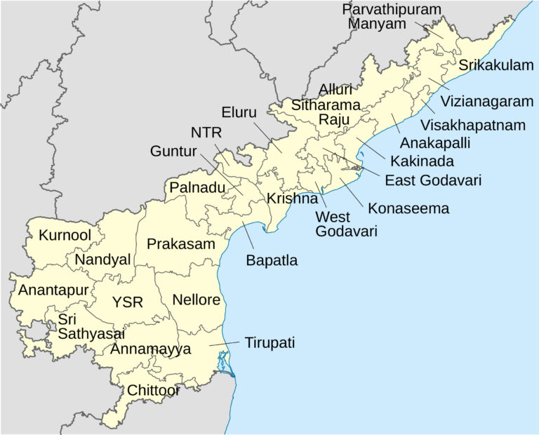
Andhra Pradesh is a state in southern India. It is bounded by Telangana to the north-west, Chhattisgarh to the north, Odisha to the north-east, Tamil Nadu to the south, Karnataka to the west, and the Bay of Bengal to the east. Andhra Pradesh is the seventh-largest state by area and tenth-largest by population in India.
The state is divided into 26 districts, which are further subdivided into mandals and villages. The districts are:
List of Districts of Andhra Pradesh
| S.N. | Code Name | District Name | District Headquarters | Population | Area (in sq.km) |
| 1 | SR | Srikakulam | Srikakulam | 2,191,471 | 4,591 |
| 2 | PM | Parvathipuram Manyam | Parvathipuram | 925,340 | 3,659 |
| 3 | VZ | Vizianagaram | Vizianagaram | 1,930,811 | 4,122 |
| 4 | VS | Visakhapatnam | Visakhapatnam | 1,959,544 | 1,048 |
| 5 | AS | Alluri Sitharama Raju | Paderu | 953,960 | 12,251 |
| 6 | AK | Anakapalli | Anakapalli | 1,726,998 | 4,292 |
| 7 | KK | Kakinada | Kakinada | 2,092,374 | 3,019 |
| 8 | EG | East Godavari | Rajahmundry | 1,832,332 | 2,561 |
| 9 | KN | Konaseema | Amalapuram | 1,719,093 | 2,083 |
| 10 | EL | Eluru | Eluru | 2,071,700 | 6,679 |
| 11 | WG | West Godavari | Bhimavaram | 1,779,935 | 2,178 |
| 12 | NT | NTR | Vijayawada | 2,218,591 | 3,316 |
| 13 | KR | Krishna | Machilipatnam | 1,735,079 | 3,775 |
| 14 | PL | Palnadu | Narasaraopet | 2,041,723 | 7,298 |
| 15 | GU | Guntur | Guntur | 2,091,075 | 2,443 |
| 16 | BP | Bapatla | Bapatla | 1,586,918 | 3,829 |
| 17 | PR | Prakasam | Ongole | 2,288,026 | 14,322 |
| 18 | NE | Sri Potti Sriramulu Nellore | Nellore | 2,469,712 | 10,441 |
| 19 | KU | Kurnool | Kurnool | 2,271,686 | 7,980 |
| 20 | NN | Nandyal | Nandyal | 1,781,777 | 9,682 |
| 21 | AN | Anantapur | Anantapur | 2,241,105 | 10,205 |
| 22 | SS | Sri Sathya Sai | Puttaparthi | 1,840,043 | 8,925 |
| 23 | CU | YSR | Kadapa | 2,060,654 | 11,228 |
| 24 | AM | Annamayya | Rayachoti | 1,697,308 | 7,954 |
| 25 | TR | Tirupati | Tirupati | 2,196,984 | 8,231 |
| 26 | CH | Chittoor | Chittoor | 1,872,951 | 6,855 |
Andhra Pradesh Map in Hindi | AP District Map in hindi
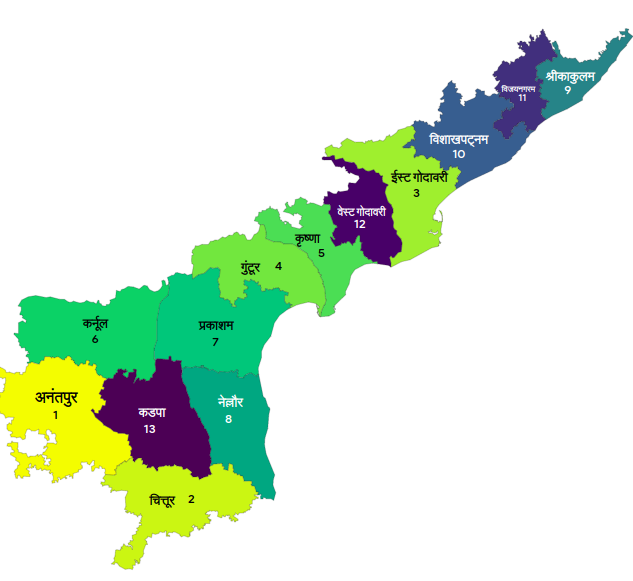
The district map of Andhra Pradesh is a useful tool for planning travel, business, and other activities. The map shows the location of all the districts in the state, as well as major roads, railways, and airports. The map is also helpful for identifying the different regions of Andhra Pradesh, each of which has its own unique culture and history.
The district map of Andhra Pradesh is available online and in print. The online map can be accessed by visiting the website of the Andhra Pradesh government. The print map can be purchased from bookstores and other retailers.
Here are some of the major tourist attractions in each district of Andhra Pradesh:
- Srikakulam: Simhachalam temple, Srikurmam bird sanctuary, Kalingapatnam fort
- Vizianagaram: Vizianagaram palace, Araku Valley, Borra Caves
- Parvathipuram Manyam: Belum Caves, Papikonda National Park
- Alluri Sitharama Raju: Koduru forest, Veerapuram fort
- Visakhapatnam: Visakhapatnam beach, Kailasagiri, Dolphin’s Nose
- Anakapalli: Bheemunipatnam, Visakhapatnam Museum
- Kakinada: Kakinada Beach, Godavari estuary
- Dr. B. R. Ambedkar Konaseema: Konaseema backwaters, Uppalapadu bird sanctuary
- East Godavari: Adivaram waterfalls, Undavalli Caves
- West Godavari: Bhimavaram temple, Undi beach
- Eluru: Eluru Fort, Kolleru Lake
- Krishna: Vijayawada, Amaravati, Undavalli Caves
- NTR: Narsapuram temple, Buggarapu Konda
- Guntur: Guntur Fort, Undavalli Caves
- Palnadu: Kolli Hills, Tangutur Fort
- Bapatla: Bapatla Fort, Mangalampalli
- Prakasam: Markapur Fort, Parchur
- Sri Potti Sriramulu Nellore: Nellore Fort, Belum Caves
- Kurnool: Kurnool Fort, Belum Caves
- Nandyal: Nandyal Fort, Belum Caves
- Anantapuramu: Srikalahasti temple, Belum Caves
- Sri Sathya Sai: Puttaparthi, Prasanthi Nilayam
- YSR: Kadapa Fort, Belum Caves
- Annamayya: Annamayya temple, Belum Caves
- Tirupati: Tirumala Tirupati temple, Venkateswara Swamy temple
- Chittoor: Chittoor Fort, Belum Caves
The district map of Andhra Pradesh is a valuable resource for anyone planning to visit the state. The map can help you plan your itinerary, find your way around, and discover the many attractions that Andhra Pradesh has to offer.
Facts about Andhra Pradesh |
|
|---|---|
| Founded | 1 November 1956 |
| Capital City | Amaravati |
| Area | Approximately 160,205 sq. km |
| Population | Over 54 million |
| Official Language | Telugu |
| Sex ratio | 997 females per 1000 males |
| Literacy rate | 67.35% |
| GDP (nominal) | ₹13.7 trillion (US$170 billion) |
| GDP (PPP) | $240 billion |
| Chief Minister | Y.S. Jaganmohan Reddy |
| Governor | Biswabhusan Harichandan |
| Assembly | 175+58 seats |
| Lok Sabha | 25 seats |
| Rajya Sabha | 11 seats |
| Dialects | Telangana, Rayalaseema, and Coastal Andhra dialects |
| Major Cities | Visakhapatnam, Vijayawada, Tirupati, Guntur, and Rajahmundry |
| Climate | Tropical climate with hot summers and moderate winters |
| Rainfall | Heavy rainfall during the monsoon season |
| Famous Personalities | N. T. Rama Rao (Actor and Politician), P. V. Sindhu (Badminton Player) |
| Major Rivers | Krishna River and Godavari River |
| Religion | Predominantly Hindu with significant Muslim and Christian communities |
| Festivals | Ugadi, Sankranti, Vinayaka Chaturthi, Maha Shivaratri, Diwali, and Christmas |
| Cuisine | Spicy and flavorful, known for dishes like Hyderabadi Biryani, Gongura Chicken, and Pesarattu |
| Tourist Attractions | Tirupati Balaji Temple, Araku Valley, Golconda Fort, Vizag Beach, Borra Caves |
| State Symbols | State Bird: Indian Roller, State Animal: Blackbuck, State Tree: Neem, State Flower: Water Lily |